Selecting Potential Water Harvest Sites Using GIS and Remote Sensing In Al-Tharthar Valley, West Nineveh, Iraq.
Article Sidebar
Main Article Content
Abstract
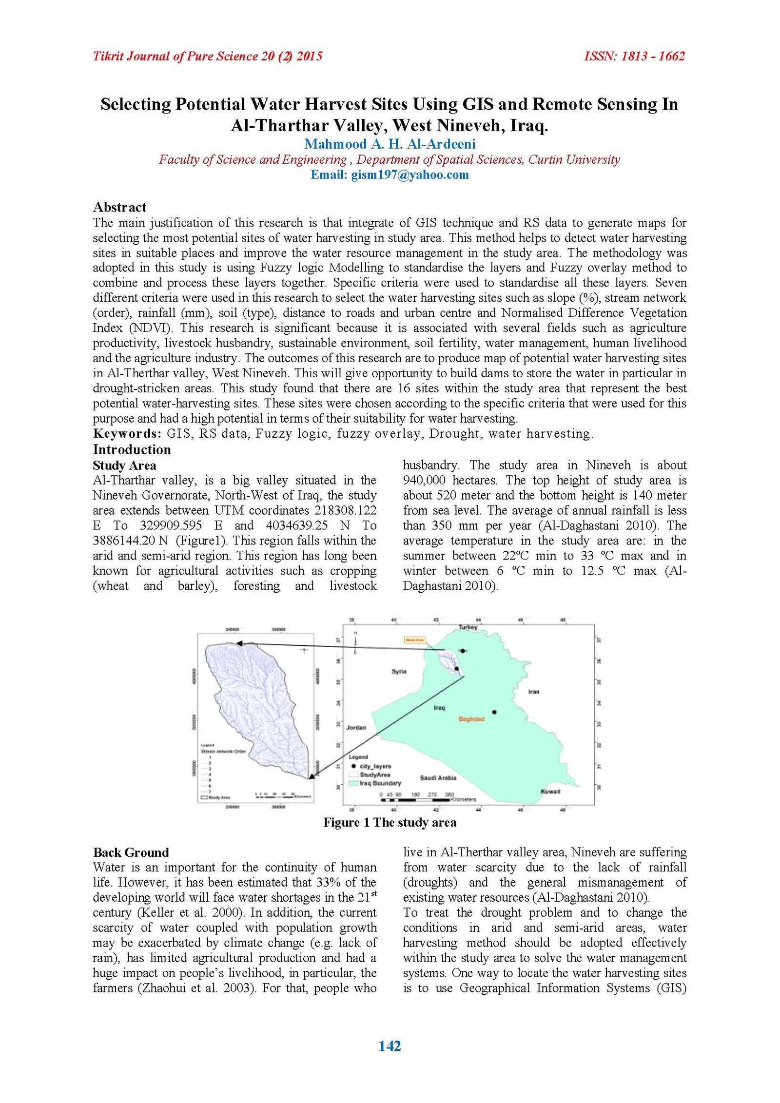
The main justification of this research is that integrate of GIS technique and RS data to generate maps for selecting the most potential sites of water harvesting in study area. This method helps to detect water harvesting sites in suitable places and improve the water resource management in the study area. The methodology was adopted in this study is using Fuzzy logic Modelling to standardise the layers and Fuzzy overlay method to combine and process these layers together. Specific criteria were used to standardise all these layers. Seven different criteria were used in this research to select the water harvesting sites such as slope (%), stream network (order), rainfall (mm), soil (type), distance to roads and urban centre and Normalised Difference Vegetation Index (NDVI). This research is significant because it is associated with several fields such as agriculture productivity, livestock husbandry, sustainable environment, soil fertility, water management, human livelihood and the agriculture industry. The outcomes of this research are to produce map of potential water harvesting sites in Al-Therthar valley, West Nineveh. This will give opportunity to build dams to store the water in particular in drought-stricken areas. This study found that there are 16 sites within the study area that represent the best potential water-harvesting sites. These sites were chosen according to the specific criteria that were used for this purpose and had a high potential in terms of their suitability for water harvesting.
Article Details

This work is licensed under a Creative Commons Attribution 4.0 International License.
Tikrit Journal of Pure Science is licensed under the Creative Commons Attribution 4.0 International License, which allows users to copy, create extracts, abstracts, and new works from the article, alter and revise the article, and make commercial use of the article (including reuse and/or resale of the article by commercial entities), provided the user gives appropriate credit (with a link to the formal publication through the relevant DOI), provides a link to the license, indicates if changes were made, and the licensor is not represented as endorsing the use made of the work. The authors hold the copyright for their published work on the Tikrit J. Pure Sci. website, while Tikrit J. Pure Sci. is responsible for appreciate citation of their work, which is released under CC-BY-4.0, enabling the unrestricted use, distribution, and reproduction of an article in any medium, provided that the original work is properly cited.
References
1. Ahamed, TRN, Rao, KG & Murthy, JSR 2000, 'GIS-based fuzzy membership model for crop-land suitability analysis', Agricultural Systems, vol.63, no.2, pp.75-95.
2. Al-Adamat, R 2008, ‘GIS as a decision support system for siting water harvesting ponds in the basalt aquifer/NE Jordan’, Journal of Environmental Assessment Policy and Management, vol. 10, no. 2, pp. 189-206.
3. Al-Daghastani, H S 2010,'Water harvesting search in Ninevah Governorate using remote sensing data', Iraqi journal of desert studies, vol. 2, no. 1, pp.1-17.
4. Al-Ardeeni, M H & Robinson T 2013, 'Locating Suitable Water Harvest Sites Using Geographic Information Systems and Remote Sensing in West Nineveh, Iraq'. Thesis.
5. Ashraf, M, Kahlown, MA & Ashfaq, A 2007, 'Impact of small dams on agriculture and groundwater development: A case study from Pakistan’, Agricultural Water Management, vol.92, no.1,pp. 90-98.
6. Assimakopoulos, JH, Kalivas, DP & Kollias, VJ 2003, ‘A GIS-based fuzzy classification for mapping the agricultural soils for N-fertilizers use’, Science of the Total Environment, vol. 309, no. 1-3, pp. 19-33.
7. Aydi, A, Zairi, M & Dhia, HB 2013, ‘Minimization of environmental risk of landfill site using fuzzy logic, analytical hierarchy process, and weighted linear combination methodology in a geographic information system environment’,
Environmental Earth Sciences, vol. 68, no. 5, pp. 1375-1389.
8. Benz, UC, Hofmann, P, Willhauck, G, Lingenfelder, I & Heynen, M 2004, ‘Multi-resolution, object-oriented fuzzy analysis of remote sensing data for GIS-ready information’, ISPRS Journal Of Photogrammetry And Remote Sensing, vol.58, no.3-4, pp.239-258.
9. Ghayoumian, J, Mohseni Saravi, M, Feiznia, S, Nouri, B & Malekian, A 2007, ‘Application of GIS techniques to determine areas most suitable for artificial groundwater recharge in a coastal aquifer in southern Iran’, Journal of Asian Earth Sciences, vol. 30, no. 2, pp. 364-374.
10. Jamali, I A, Olofsson, B & Mortberg U 2013, ‘Locating suitable sites for the construction of subsurface dams using GIS’, Environ Earth Sciences, DOI 10.1007/s12665-013-2295-1,pp.1-15.
11. Jasrotia, A, Majhi, A & Singh, S 2009, 'Water balance Approach for rainwater harvesting using Remote Sensing and GIS Techniques, jammu Himalaya, India', Water Resources management, vol.23, no.14, pp.3035-3055.
12. Kallali, H, Anane, M, Jellali, S & Tarhouni, J 2007, ‘GIS-based multi-criteria analysis for potential wastewater aquifer recharge sites’, Desalination, vol. 215, no. 1-3, pp. 111-119.
13. Keller, A, Sakthivadivel, R, & Seckler, D 2000, 'Water scarcity and the role of storage in development', Colombo Sri Lanka: International Water Management Institute (IWMI), vii, 20p. (Research report 39).
14. Lu, CY, Gu, W, Dai, AH & Wei, HY. 2012, ‘Assessing habitat suitability based on geographic information system (GIS) and fuzzy: A case study of Schisandra sphenanthera Rehd. et Wils. in Qinling Mountains, China’, Ecological Modelling, vol.242, no.11,pp.105-115.
15. Malczewski, J 2006, ‘GIS-based multi-criteria decision analysis: A survey of the literature’, International Journal of Geographical Information Science, vol. 20, no. 7, pp. 703-726.
16. Oweis, T, Hachum, A & Kijne, J 1999,'Water harvesting and supplementary irrigation for improved water use efficiency in dry areas, SWIM Paper 7. Colombo, Sri Lanka’, International Water Management Institute.
17. Pandey, A, Chowdary, V M, Mal, B C & Dabral, P P 2010,'Remote sensing and GIS for identification of suitable sites for soil and water conservation structures', Land Degrad. Develop, vol.22, pp.359–372.
18. Pathaknad, D R & Hiratsuka, A 2011, ‘An integrated GIS based fuzzy pattern recognition model to compute groundwater vulnerability index for decision making’, Journal of Hydro-Environment Research, vol. 5, no. 1, pp. 63-77.
19. Reshmidevi, TV, Eldho, TI & Jana, R 2009,'A GIS-integrated fuzzy rule-based inference system for land suitability evaluation in agricultural watersheds', Agricultural Systems, vol.101, no.1-2, pp.101-109.
20. Robinson VB 2003,’A perspective on the fundamentals of fuzzy sets and their use in geographic information systems’, Transaction in GIS, vol.7, no.1, pp.3-13.
21. Shirke, A j, Suryawnshi, R A & potdar, D V 2010 ‘Sustainable water resource management of pawas watershAed using remote sensing and GIS’, Indian Geotechnical Conference, vol. 1, no. 134, pp. 1091-1094.
22. Tahsin A Y, Zuhal A 2006,' The enhancement of the cell-based GIS analyses with fuzzy processing capabilities', Information Sciences, vol. 176, pp. 1067–1085.